Travel Blog


Hiking Shoes And Thin Socks – A Backpacking Winner

April 1st, 2017 ernie Posted in Hiking No Comments »

Hiking shoes versus hiking boots? Hiking shoes win. Okay, next issue? No, really. Hiking or running shoes are better for most backpacking trips, at least during late spring, summer and early fall. Boots are heavy, hot, stinky, and stay wet forever. A pound on your feet is like five on your back (some say six), so three-pound boots leave you much more tired at the end of the day.

Hiking Shoes And Ankle Support

You may have heard arguments for the necessity of ankle support,but throughout history people managed without stiff ankle-supporting boots. The problem is weak ankles, not a lack of support. You can solve this by walking a little each week on uneven ground (not in the mall).

Some may need boots, but be sure your ankle problems are not just due to a lack of exercise before you settle for backpacking in hiking boots. You may also need hiking boots if you carry more than thirty pounds when you backpack. Cut the weight down,though, and you’ll be more comfortable anyhow.

Why Running Or Hiking Shoes?

Feet stay cooler in a good running shoes than in hiking boots.This means fewer blisters. After switching to running shoes and lightweight socks years ago, I stopped getting blisters. I don’t mean fewer blisters. I mean haven’t had one blister since I switched. Not even after a 110-mile 7-day trek in the Rockies,for example.

Hiking Shoes And Thin Socks – A Backpacking Winner

How To Choose Your Shoes

Try to keep below two pounds per pair, unless you have size 13feet. If the weights are not shown in a catalog, you’ll have to guess which are lighter based on the description and photo. Quality shoes have soles stitched to the uppers, so look under the insoles (a removable insole is another sign of quality shoes). You can usually find a good pair of running shoes that weighs less than 28 ounces for under $80, or half of that on close outs.

There’s nothing quite as liberating as ditching the heavy pack and heavy boots and hitting the trail in running shoes. You get to go more miles, and in comfort. You get to run up a hill just to see what’s there. I have yet to meet a person who has tried backpacking in hiking or running shoes – and then returned to boots.

AddThis Social Bookmark Button

Hiking to Murray Peak Palm Springs

February 24th, 2014 ernie Posted in Hiking No Comments »

The view from Marie Peak is spectacular. As shown in this panoramic view of the Coachella Valley played out for us. I took this picture with my iPhone 5. It is a 270 degree panoramic view from the top of Murray Peak in Palm Springs.

Murray Peak Murray Peak is located in the Coachella Valley near Palm Springs. It is approximately 2100 feet high with a 1500 foot elevation climb from the trail head. Although a 2100 feet elevation does not seem like much,  it certainly is when you are hiking up to the top of the peak.

Time to the Top of Murray Peak

This particular hike takes approximately 2 1/2 hours to reach the top and almost 2 hours to do sand. The hiking is very gradual in places while challenging in others.

Murray Peak There are lots of switchbacks to traverse while you’re climbing up the mountain although in some areas it can be a very gentle rise. There are five picnic tables at the top of the peak where you can enjoy your lunch, snack or just relax. There’s also cell phone service at this location. There are two trail heads that lead to the top of Murray peak. One can be found at Von’s along Highway 111 and the other from the South Indian Palm Canyon area.

Take lots of water, and something to eat as this hike will take you approximately five hours to reach Murray Peak and return round-trip. Wear lots of sun tan lotion and cover your head. The sun can get pretty intense and you really need to make sure that you are prepared for this hike.

Wear very good hiking shoes as well and carry a hiking stick with you. It helps with balance and provides protection from any animals that you may encounter. Note that the writer has hiked to the top of Murray Peak several times and we have never seen any animals  while on our hike.

For more posts about hiking and all topics associated with hiking, click here.

AddThis Social Bookmark Button

Palm Springs – hiking and biking

February 8th, 2014 ernie Posted in Hiking No Comments »

Palm Springs – hiking and bikingThe Palm Springs area has many outdoor activities for those people who are interested in that sort of thing. If you want to get away from the pool, shopping or playing golf, there is lots of hiking and biking that just about anyone can take part in. Palm Springs – hiking and biking activities are supported by volunteer organizations in the valley which many people benefit from.

This picture was taken near the San Andreas fault line. An Oasis in the background of this picture is only here because of water that seeps up through the fault. It provides water for the palm trees. In the middle of the desert with nothing else around it is always amazing to see It is an area like this that seems to exist somehow in the dry desert.

In this area, there are at least 4 oasis within a mile radius. There is dry desert in between all courtesy of the San Andreas fault that runs north to south just a few miles from Palm Springs. You cannot really see the fault. However there are signs and there are volunteers that are at another oasis with an information center. You can learn all about the fault, the oasis and the palm trees that grow in this area.

Palm Springs – hiking and biking – Safety

When do go hiking, regardless of how far you plan to go, always tell someone where you plan to go. Always take water with you. Even a short hike can be difficult if you do not have adequate water with you in the dry hot desert. The water in this particular oasis is not drinkable due to the sulfur content. There are other minerals that exist in the water as well. Of course if you are biking within the city, there are lots of stores to stop at to get some water. Most coffee shops will provide glasses of water for free. However if you head out into the desert areas or in areas with lower population, make sure you have water with you. Dehydration can set in very quickly in the high temperatures.

AddThis Social Bookmark Button

Joshua Tree Park

July 21st, 2013 ernie Posted in Hiking No Comments »

Joshua Tree ParkJoshua Tree Park has fantastic views and is a great place for hiking and rock climbing. There are many trails  to hike as well and there are many places to camp. Bringing enough water is probably the single most important thing to remember. When we visited the park it was probably 100F in the valley. But up in the park which is at a higher elevation, the temperature was probably 20 degrees lower in temperature. In the high desert which is where  Joshua tree Park is located, it can become quite cold at night. Campers are urged to bring warm clothes and sleeping bags when they camp out under the stars.

There is no fuel to be collected and burned. In fact the park has very strict rules about camping and fires. They urgently want to avoid fires getting out of control in the dry conditions. They do not want people taking some of the local brush and using that for firewood. Bring your own if you intend to have a fire.

20130421-123724.jpgJoshua Tree Park

This park is in the high desert and visitors can drive up to a look out that over looks the Coachella Valley, where the cities of Palm Springs, Cathedral city, Rancho Mirage and several other desert cities are located.

On a beautiful sunny day you can see for up to 100 miles and on some days you can see all the way to Mexico. If you are planning to visit Joshua Tree park, we suggest you wait until there is little wind that is not blowing the dust around and making the visibility much less than a 100 miles.

Save

AddThis Social Bookmark Button

Joshua Tree California

July 8th, 2013 ernie Posted in Hiking No Comments »

Joshua Tree CaliforniaThe town of Joshua Tree California is aptly named since it is
in the middle of the Joshua tree forest and next door to the Joshua
tree national park. This is a really great place to go hiking. Many people also camp under the stars. If you go take lots of water, warm clothes, it gets cold at night and tell someone where you are going in case you need to be rescued.

Joshua Tree California

These pictures were taken in the park which is
roughly ten miles from the town. The elevation is somewhere around 6000 feet and there are look out points in the park that over look the Coachella valley with the towns of Palm Springs, Cathedral city, Rancho Mirage, Indio etc. The climate is always much cooler compared to the desert. You can typically find the temperatures at least 20 degrees cooler and much stronger winds as well. Many people from the desert communities will head up into the high desert in the summer time to get away from the extreme heat.

The desert communities can hit 120 degrees F, while in the high desert is only 100F. It might not seem like a lot, but anytime it is 20 degrees cooler you appreciate it.
20130423-210929.jpgThere is lots of camping and hiking available in the park. The town of Joshua Tree also has several hotels to stay at. They also have a Walmart and several coffee shops including a Starbucks to stop at. There is a park information center in the town. It has a lot of great information about the park, the hikes, camp sites and the many animals that live in and around the area.

For more posts about hiking and all topics associated with hiking, click here.


AddThis Social Bookmark Button

Joshua Tree National Park

May 5th, 2013 ernie Posted in Hiking No Comments »

Joshua Tree National ParkJoshua Tree National Park offers stupendous views of the Coachella valley as seen in this picture overlooking Palm Springs and the other valley cities. The Joshua trees, the rocks, the mountains and the desert provide scenes that you find amazing. The height of these mountains on the eastern side of the valley are between 6000 and 8000 feet. They  provide stupendous views of the valley.

Joshua Tree National Park – Scenery

Tourists can drive through the park and in particular up to a lookout point that is within a few hundred feet of the look out point.20130418-162325.jpg

Try to go up to the lookout point on a sunny day and when it is not too windy.  Even on days when there is little wind in the valley there is always wind at this elevation. the mountains to the North and to the West are above 11,000 feet. In fact you can take the Tram up to the western mountains which takes you to 8500 feet . There are many hiking trails in this area, up to 54 miles at last count of hiking trails.

Of course there are many hiking trails as well as camping trails in the Joshua park as well, with numerous places to hike as well as camp or park an RV. Campers should note that everything they take in with them must also come out with them. Please keep the park pristine and enjoyable for other campers.


Save

AddThis Social Bookmark Button

Hiking in San Jacinto Mountains

May 1st, 2013 ernie Posted in Hiking No Comments »

Hiking in San Jacinto MountainsThere are is great Hiking in San Jacinto Mountains. There are 54 miles of hiking trails at the top of the tram in Palm Springs. Which is located in the San Jacinto mountains. The highest mountain is over 10,000 feet in elevation in this area. Hikers can observe stunning views of the mountains and valleys just minutes away from the desert valley.

There can be a twenty degree drop in temperature from the valley floor during a trip up the tram in the summer time. It can provide a welcome relief to the searing temperatures in the valley. In addition it provides a healthy alternative as well. All of the trails are well groomed and marked for most trails.

Hiking in San Jacinto Mountains

Hikers should remember to always tell someone where they are going. Always bring extra clothes and especially lots of water with you. Especially in dry conditions hikers can become dehydrated very easily. It actually can get quite cool at night if you happened to be stranded over night int he forest.

This area is truly a hikers paradise. Thousands of people go up the tram every week to take advantage of the scenery, the solitude and the healthy mountain air. There are over 54 miles of trails that take you into the back country and wilderness areas. Several people are rescued every year because they got lost. In addition they also were not well equipped with water, food and warm clothing to deal with night time temperatures.

If you plan to hike in these areas take the time to be well prepared. Make sure you have the above mentioned item as well as a compass and a light warm blanket. It can be quite surprising to find out that you are suddenly lost with no idea of how to get back to the trail head. If no one knows that you have gone hiking they will not be looking for you. In addition always tell someone where you are going and when you will be expected to return.

Save

AddThis Social Bookmark Button

Grapevine Canyon Nevada

February 28th, 2013 ernie Posted in Hiking No Comments »

Grapevine Canyon Nevada
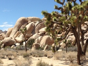
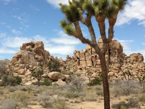
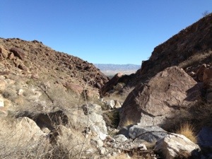
Grape Vine canyon in southern Nevada is a really great place to go hiking and enjoy the scenery of the desert. This particular canyon is located not far from Laughlin Nevada. It is just off route 163 leading to route 95 and Las Vegas. The turn off is about half way up the mountain on your right as you head up the mountain from Laughlin, Nevada.

The road is a dirt road and there are signs leading to the parking lot for the Grapevine Canyon Trail head.  You can continue on further on the dirt road to Christmas tree peak, however it is really not for cars. SUV’s and jeeps are better suited for this terrain. It is just a bit too rough for a normal car with a lower suspension compared to an SUV or a jeep.

Grapevine Canyon Nevada

The hike is a nice easy hike and there is some shade, but not a lot. Take lot’s of water with you and make sure that you have applied sunscreen as well. Since you can easily burn in the hot sunny blue skies of southern Nevada. We spent about half a day enjoying this hike. It is suitable for most casual hikers  who want to get out in the desert. But not too strenuous. We enjoyed our day very much before heading back to Laughlin and the Aquarius casino hotel were we were staying.

Anyone going for a hike in the desert should always take lots of water with them. they should also wear a hat to protect them from the sun. Of course sun screen should be applied liberally. Wear proper clothes and hiking boots. Every year some people get into trouble by not being properly  prepared to hike in the desert. They need to be rescued due to dehydration or getting lost in the desert.

Always tell someone where you are going whether it is to Grapevine canyon Nevada or somewhere else. Let them know when you will return so that if needed rescue efforts can be expedited to the right location.

Save

AddThis Social Bookmark Button

Hiking on the Art Smith trail Palm Springs

February 17th, 2013 ernie Posted in Hiking No Comments »

Hiking on the Art Smith trail Palm SpringsWe were hiking on the Art Smith trail Palm Springs the other day. It starts off of Highway 74, in Palm Desert and heads across a drainage reservoir, and then almost straight up on a well-defined trail. Eleven miles in length with a number of oases’ along the way that you can stop at to take a short break, rest a bit, or grab a quick bite.

We only made it to the second oasis, which was about 3 miles. That was enough for us. It was almost 80 degrees with no breeze at all. We found that with the sun beating down on us, it gets quite warm.

Hiking on the Art Smith trail Palm Springs – Water

We had lots of water with us and we cannot stress this enough for anyone hiking in the desert. Always take water with you and always take more than you think you will need. It does not take long to get dehydrated in the desert and that just brings serious problems if you have no one to help you.

20130217-164730.jpgThe Art Smith Trail is a great hike with lots of scenery and beautiful views of the valley. Take your time, take pictures, and take extra water with you always to ensure an enjoyable day. Oh, and don’t forget a hat as well as sunscreen to make your day more enjoyable!

For more posts about hiking around Palm Springs, click here.

Save

AddThis Social Bookmark Button

Hiking Around Palm Springs

February 14th, 2013 ernie Posted in Hiking, Palm Springs No Comments »

There are many places to go hiking in and around Palm springs. We will list them as we go hiking on  some of them and add pictures as well

  • The Palm Springs Museum Trail
  • Ramon
  • The Clara Burgess – This trail takes you to the top of Murray Hill.
  • Whitewater Canyon Nature Preserve
  • Tram
  • Borrego Springs
  • Pushwala
  • Murray Peak

Hiking Around Palm SpringsThese pictures were taken at a trail near the end of the Ramon trail on the north side of the city. Access is a bit difficult. You have to park on the street and walk to the end of the street. Then along a wire fence until you come to an opening which you can crawl through.

This particular area is actually a large wash that has a dike or dam across it to protect the city from flooding. Water comes down off the mountains over the cliff you see in the distance and then down into this wash. It is huge and can control / contain a great deal of water. It is also very nice to hike in. You can go all the way up to the cliff in the far distance. There is a lone palm tree sitting at the very top of the white cliff you see in the distance.

Views are Fantastic

20130213-122137.jpg This is an example of the views you see when you are standing with the cliff immediately behind you. The rocks are pretty rough and tumbled and hiking is something you must take carefully to avoid breaking a leg or scaring up a snake or two.

this hike took us about 3 hours although it really does not look as if it should take as long as it did. The distances are disbelieving in the desert and you usually end up walking much further than what was originally planned.


20130213-123152.jpgIf you are interested in seeing where the earthquake zone is and the San Andreas fault line, head out to the end of the Ramon Road into Pushwalla. there is a cabin staffed by volunteers who can fill you in on the fault line, why there are palm trees in this area and sulphate hot springs as well.

The entire area is really one big fault line which is where the pacific plate meets the North American plate. I forget which one is going under the other, but apparently that is what is happening in this area.

Murray Peak is one of the fun hikes, although it has just about everything from flat sections to steep switch backs. It takes about two and a half hours to go up and around two hours to come down. There are picnic tables at the top and you need to take lots of water and something to eat when you go.

For more things to do around Palm Springs, click here.

Save

AddThis Social Bookmark Button

Ottawa river

January 27th, 2013 ernie Posted in Hiking No Comments »

These two pictures were taken just east of the parliament buildings in Ottawa, Ontario, Canada. on the Ottawa River. We were with some friends who have a boat that they moor at one of the marina’s on the river. We boated from this location up to the parliament buildings, back to the Gatineau river and up this river to the inlet that takes you to the Hull Casino at Lac Lemay.

Ottawa river

The casino has a boat dock so we went there and tied up the boat and headed into the casino. We had something to eat, gambled a bit and then headed back to the boat to go home. This was a really nice day and we won a little bit of money as well. Our friends wanted to be off the river before it got dark, otherwise we would have stayed at the casino for a little while longer.

The Ottawa river is a great river to go boating on. It is deep and wide and for the most part quite safe. You do need to pay attention to where you are going and look for shallow locations which are marked in most places. This can be a very fun way to spend a day out on the water. Many people also go fishing as well.

For more hiking related posts, click here.

AddThis Social Bookmark Button

Visiting The Grand Canyon

April 7th, 2012 ernie Posted in Hiking 2 Comments »

The Grand Canyon
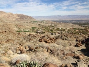
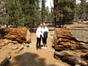
Visiting the Grand Canyon in Arizona is one of the truly neat things to do. You really cannot capture the grandeur of the Grand Canyon in a picture. We have included a couple of pictures in this post to show what the grand canyon is really like.  If you have not made a visit to one of the 7 wonders of the world, it is high time you did. We have been there several times. We have also hiked part way down the side of the south rim of the grand canyon and it is actually only when you do this that you realize just how large it is.

The Grand Canyon – Ten Miles Wide!

When you visit the grand canyon on a clear day and stand at the edge on the south rim near the grand canyon village, you can see the other side which is more than ten miles away. In fact it so grand that there can be multiple storm systems along the north rim with blue sky in between each. On the day we arrived there were three such systems on the north rim. There was blue sky between them and all across the south rim making for a truly picturesque day. We could see the lightning striking the ground from each of the storms, however they were so far away that we could not hear the sound.

Walking Down the Trail

We walked down the trail for about a 1000 feet in elevation. The trail is approximately 7 to 10 feet wide and used by hikers of course, but also mules that carry tourists down to the bottom of the canyon. We were not too excited to be share the trail with a mule train, and I sure would not want to be on one when they got excited or missed a step! It was a beautiful day and we enjoyed the sunny day and the short hike.

Note that if you plan to hike to the bottom of the trail, down to the Colorado river,  you need to plan to stay at the bottom of the canyon for the night and you must have reservations as well. There are a few camp sites and there are also is a building with bunk beds. Apparently reservations are needed almost a year in advance. We also need to advise you that unless you are in phenomenal shape, you cannot walk this trail in both directions in one day. It is just too much to try.

The Grand Canyon – Hiking the South Rim Trail

There is also a trail that runs about a mile along the edge of the South Rim that most people will find quite easy and the view is fantastic as well. It is paved so easy for wheel chairs etc to navigate along this trail while enjoying the view. The trail down to the river is of course a combination of gravel, rock and just plain dirt.

Time of Year

The south rim is approximately 6000 feet in elevation and does it get snow in the fall, winter and spring. Summers can be quite hot and of course down at the river, the temperatures rise to very high temperatures in the summer time. The water is still very cold due to its origins being snow melt in the mountains north and east of the grand canyon area.

Before you go, check with the park to find out what the typical temperatures are and remember that if you bring the extra clothes you can always take them off if it gets too hot. If you do not have them and your freezing, your going to continue freezing.

If you have been to the Grand Canyon, and would like to leave comments for our readers please do. A constructive helpful comment with a link is always helpful for our readers.

Save

AddThis Social Bookmark Button

Coachella Valley Hiking – McCallum Trail

March 12th, 2012 ernie Posted in Hiking No Comments »

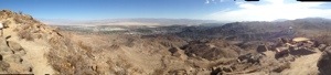
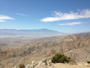
We were hiking on the San Andreas fault line the other day as part of our Coachella Valley hike on the McCallum trail. This is something I have always wanted to do and I must admit that it was almost anti climatic. We were standing on what is known as the San Andreas fault. There was really nothing to distinguish the difference from any other area around us.

In fact we visited the welcome center in the background of this picture  at the trail head. I asked how close the fault line was. The answer I received surprised me. We were standing on it. The welcome center was built on top of the fault. But back to our hiking excursion. The welcome center is located in the middle of a stand of palms and is in fact made of palm logs, dating back to 1935.

Coachella Valley Hiking – San Andreas Fault Line

The San Andreas fault runs all the way from Mexico for 700 miles up to San Francisco. It then plunges into the ocean. There are many other known fault lines that run into and away from the San Andreas fault. I wonder when this one is going to give us a big shake?

This area is known as Pushwalla. There are about 10 trails to choose from for hiking all of which are pretty easy compared to some that I have been on. You can get a map and information about the trails at the welcome center. The distance and the difficulty of each are displayed on the map. For example this is just one of the areas in the Coachella Valley.

We selected the McCallum trail which is about 2 miles and runs from one oasis to a second one. There is an actual pond in the middle of the desert. In between is hot dry desert which in itself is interesting. How can there be two different well watered oasis with palm trees in the middle of the desert on top of the San Andreas fault line?

The picture above is taken from on top of a small hill about a mile from the oasis. Which you can see in the background of this picture. It is a nice cool moist area. However there was a suspicious gas bubbling up in the middle of the pond. Never did find out what that was. However the water was crystal clear, no algae at all and no plants growing in the pond. The palm trees were all clustered around the pond.

Hiking Trails

The trail starts off on a boardwalk through the ancient palm trees. Then up into the desert grasses and then finally into the desert proper. We walked 2 miles from one oasis to the other. However it did not feel like two miles at all and the walking was not strenuous what so ever. The temperature was about 75 degrees. Although not that hot, we perspired a lot and needed the water we were carrying.

For those of you who may not be into hiking or are afraid that hiking might be too much due to the difficulty this is an excellent one to take on. You can easily do this one without difficulty. However if you do get tired or you find the heat too much, just turn around and head back to the oasis to cool off.  Always take water with you as well.  This was a short hike and I took a full  bottle with me and found I needed all of it for this short hike. Hence always bring water with you for hiking and even a small snack to give you a bit of energy if needed.

We would lie to have your comments about hiking in this area of Palm Springs and the Coachella Valley. Please leave well written comments that will be interesting to our readers.

For more posts about hiking, click here.


Save

AddThis Social Bookmark Button

Pablo and Raccoons

November 17th, 2011 ernie Posted in Hiking 2 Comments »

Pablo and Raccoons This web site is about a series of funny stories and events that have happened to my family over the last few years. Hopefully you will enjoy them as we add a new story from time to time. This particular story is about the time that a family of raccoons found their way into our attic over our living room with the intention of making our attic their home. They only stayed for a short while, however the experience is not something I would want anyone to have to deal with.

Raccoons as we found out are very curious and very smart. They climbed up a 10 foot brick wall on the side of our home onto the garage roof and then pushed up the soffit to gain access to our attic. This is pretty common in urban areas and many people every year have to deal with this kind of situation. In fact over half the houses on our street had the same problem. I did not know this until I had to deal with them and did some research on the topic of raccoons in urban areas.

They raised their young in our attic before we realized what was happening. I started trying to take steps to get them out. I tried loud noise, I tried moth balls, I tried music turned up high . I found all of these solutions on the internet and only one of these work  so don’t waste your time.

I also tried trapping them and this is where it started to get interesting. Picture a humane trap up on our garage roof next to the opening in the soffit were they get into our attic. They cannot miss it and all they have to do is walk inside the trap to get some food and bingo we have a raccoon in a trap!

Trapping Raccoons

Well it turns out that trapping the young ones was no problem. Young children no matter what species do not listen to their parents. They paid the price and found themselves in a new home in the bush. The parents have seen this before and knew enough to not go inside the trap. We put peanut butter, jam, cheese, raw meat, cooked meat and a bunch of other things to entice them into the trap. Not only did they not go in the trap. They would reach through the side of the trap to reach the food and ate almost all of it without setting off the trap!

Well one day, late in the evening, I had just finished having a shower and decided to go outside and see if there was anything inside our trap. It was near dusk and this is typically the time they come out. They are nocturnal and like to hunt for food at night. I had a pair of shorts on, bare feet and no shirt. As I come out side the door of the house is blown shut by the wind and it locked automatically so I cannot get back into the house.

The Raccoon Attacks Me

As I am standing on the front step,  looking up at the trap on the roof, a huge raccoon comes walking around the side of the house across the driveway towards me. He is obviously planning on climbing the wall beside the front step to go back to his nice warm den.

When he sees me , he is half way across the driveway and he is quite surprised as am I. He stops and looks at me for a moment and then stands on his hind feet and hisses at me. Then takes a few steps forward and does it again. He is trying to intimidate me into leaving so he can get to his home.  I am defenseless and standing in my bare feet. What can I do?

Now I am not normally afraid of small animals. However when you are in your bare feet and a raccoon is advancing and hissing at you and they have taken you by surprise , what would you do?

What Do You Do

Well a story I had heard about a guy encountering a bear in the wild came to mind. He made himself as big as possible, waving his arms and making loud noises. The bear thought better of it and decided to back off, as did the guy in the story.  So I decided to try the same thing. I am a lot larger than a raccoon and so I must have looked really big to him. Can you imagine his surprise! He stopped hissing immediately, hesitated for a second while h thought about what he should do next. I hissed again and that was enough for him. He quickly scrambled around the side of the garage, not to be seen again!

I was able to ring the doorbell and get the attention of my wife who came and opened the door. When she heard my story she could not stop laughing at me. What a wimp! No sympathy at all and every time I retell this story, I get lot’s of laughs and guffaws. No one can really believe it.  I tend to act it out a bit as well when I am telling the story so it is funny. Hopefully the written word conveys in your mind a picture of what I felt as that huge raccoon was deciding to attack me or not!

For more posts about hiking and all topics associated with hiking, click here.

AddThis Social Bookmark Button

White Water Canyon – Palm Springs

November 14th, 2011 ernie Posted in Hiking No Comments »

White Water Canyon
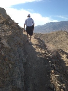
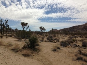
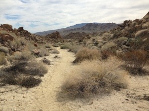
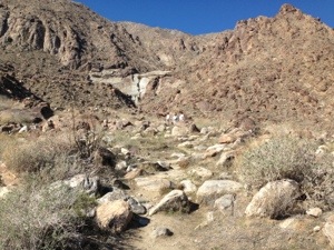
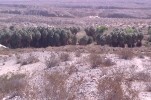
One of the great things to do in the Palm Springs area is hiking. There are many trails, most are groomed, but not monitored. Nor do they have guides and maps. The White water canyon area just outside of Palm Springs is different. There are guides and programs that you can take advantage of if you wish or you can just go hiking on your own and follow the trails.

White Water Canyon Location

This location is unique. The mountain water is diverted from the mainstream into 3 large pools of water where rainbow trout are stocked. There are literally hundreds of fish in these pools and they are reserved for fishing by children. Let’s face it there are not many places to fish in the desert.

This is one of the few places you can take your kids to fish and try out a new rod. Note: adults are not allowed to fish and the kids are asked to use barbless hooks so that the fish can be thrown back in without being harmed.

Another neat thing about this area is that there are actually mountain goats in the area. I have only seen them once and this was early in the morning when we arrived. Once it warms up they seem to seek cover from the sun so they are really hard to spot. Early in the morning, they are usually out and about.

Picnic Tables

There are picnic tables for anyone who wants to have a picnic with their families. There is lots of shade as well this is a really nice spot to spend an afternoon away from the heat of the desert. It is usually 10 to 20 degrees cooler in this area because of the elevation.

There is also limited camping in the area. Campers need to reserve a campsite, otherwise it is first come first serve.  There are not many sites so it is a good idea to call ahead. There are also volunteers at the site along with park wardens. They have lots of information about the area.

There is a large topographical map where you can view the roads, and the hiking paths and get an orientation of where you are. When we look at this map we were impressed with just how large the entire area is around the white water canyon and the overall drainage area of this particular stream.

This is one of the locations where you can also link up with the Pacific Coast trail which runs from the Mexican border all the way to Canada. The writer has not hiked on this particular trail, however, many people do every year and enjoy the scenic vistas that it presents. This is really for serious hikers only.

Canyon Formation

The White Water canyon area was formed and is still being formed by water runoff from melting snow caps in the mountains above the canyon as well as storm runoff. Everywhere you look you can see the results of the strong floods that have shaped this area.

These pictures show the wide swath the stream takes when it is at flood stage. At this particular time when we were there, which was Oct, the stream is fairly small and just dealing with snow melt from the nearby mountains.

There are small bridges built across the stream to make crossing easier. In most cases, though you just jump from rock to rock to get across any water areas. The park wardens are constantly monitoring the runoff and will make repairs whenever they are washed away by floods.

For more hiking places to consider, click here.

Save

AddThis Social Bookmark Button

White Water Canyon – Palm Springs

November 5th, 2011 ernie Posted in Hiking No Comments »

This a short post to alert hikers to a great place to hike in the Palm Springs area. There are many places to hike, however this is one of my favorites so far to spend a little time. We have gone out to this location White Water Canyon Palm Springs several times over the past years and always enjoy the time spent there.

The best time to go is early in the day, when it is still cool. You do not need to worry about the heat too much. Always make sure you take lots of water with you to avoid any dehydration issues.  Always bring a hat and sun tan lotion. If you plan to go on a serious hike, tell someone were you are going and hike with a partner. Also if you go early in the morning there is a good chance that you will spot a couple of big horn mountain sheep on the surrounding mountains. Twice now we have just missed then after we arrived at 10 in the morning. Get there early if you want to see them live on the mountains.

Hiking in White Water Canyon Palm Springs

We know that everyone is looking for a variety of things to do. Hiking may not be what everyone is looking for. Perhaps you just want to get away from the heat in Palm Springs. Or just want to have a family picnic around under the tree’s. There is lots to do for the day so here is a quick list of the advantages of this particular location in no particular order:

  • Well groomed trails which are repaired any time there is a flood
  • Several trails to choose from that vary from easy to medium in difficulty
  • Maps available for hikers
  • Links with Pacific Coast trail
  • Camping sites available although there is a limited number and it is encouraged that campers reserve ahead of time
  • Picnic tables at the main site were all of the trails begin
  • Volunteers available to provide information and assistance to hikers
  • Trout ponds for the kids to go fishing – catch and release; 3 ponds stocked with fish
  • Occasional sightings of big horn sheep on the surrounding mountains

Take a few minutes and speak with one of the volunteers in the main cabin and you will learn lots of things about the area. Most are serious hikers and can provide lots of information that will be of use to you. On the day we went to the Whitewater canyon area, the volunteer told us about how everything got started and how it ended up as a park for people to hike in with rainbow trout that you can catch in the desert!

Fishing At White Water Canyon Palm Springs

If you decide to try fishing, remember that it is catch and throw back and you must use barb less hooks to protect the fish from being damaged. Also fishing is for the kids and there will be someone around to assist them with how to fish, how to cast and pulling the fish in, if needed. This is a really great place to spend a few hours and get away from the desert, although it is all around you.

For more hiking related posts, click here.

AddThis Social Bookmark Button


?>


Web Content Development