

American River Rafting
 The three forks of the American River begin in the peaks of the Sierra Nevada range in Northern California. From there they meander through granite canyons into the rolling foothills of the gold country. The three forks range in difficulty from Class II (beginner) to Class IV+ (advanced).
The South Fork American is one of the most popular whitewater rafting rivers in the western United States. It jostles over friendly Class II-III rapids and meanders through the historic gold-mining town of Coloma. The Middle Fork American careens through a secluded canyon over numerous Class IV rapids, including infamous Tunnel Chute Rapid. The North Fork American relies on snow melt for its flows rather than upstream dam releases. Consequently, this American River rafting classic only runs in the spring.
South Fork American River Rafting
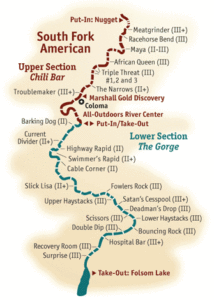
South Fork American River rafting is not recommended for inexperienced rafters, kayakers or inner-tubers (with the exception of the Coloma to Lotus section). The South Fork is Class III with some tricky and potentially dangerous rapids. The river gradient is a steep, exciting 30 feet per mile in the upper gorge from Chili Bar to Trouble Maker, easing to 9 feet per mile through the Coloma Valley. Another area becoming 33 feet per mile through the lower gorge.
The South Fork of the American is unusual in that most of the land along the river is privately owned. Homeowner’s, commercial rafting companies, private boaters, ranchers, anglers and picnickers all share this beautiful river. Above all follow proper etiquette while on the river.
Middle Fork of the American River
The Middle Fork of the American River runs through the scenic Sierra Foothills of Tahoe National Forest. The Oxbow to Greenwood run is class III-IV with one Class V (Tunnel Chute). Likewise with crews of people with at least Class III river experience who are ready for a strenuous and sometimes dangerous river adventure. As a result it is an order of magnitude more difficult than the South Fork of the American.
North Fork American River
The North Fork American is the most difficult of the three Forks. Towering Cliffs and 2000 foot canyon walls spotted with black oaks and varying pines sets the back drop. Hence this is one of the most beautiful California whitewater rafting river canyons. Located near Interstate 80, near the city of Auburn, the North Fork is easily accessible with some camping options nearby.
The Colfax-Iowa Hill Bridge to Ponderosa Way Bridge run is the most popular section to run. As a result it has been a favorite for California rafters and kayakers since the mid seventies. This 9.5 mile run contains many steep drops and boulder slaloms. Hence providing some of the best whitewater rafting of the 3 forks of the American river.
No Dams
The North Fork American, with no dams upstream, is truly a wild river. Most noteworthy it can be run by raft, canoe, or kayak in winter and spring only, when water exceeds about 900 cubic feet per second (cfs). At all levels, the river is Class IV with little rescue access. The North Fork American is a highly technical river. It should only be attempted by very experienced whitewater boaters who have seen its rapids before. A mile-by-mile guide cannot replace the judgment of each individual boater.
The North Fork is as dangerous a river to boat at low flows as at high flows. Several drownings and injuries have occurred at low flows due to underwater sieves. Above about 1500 cfs most dangerous rocks are covered and passages are wider, and maneuvering is much easier. But at flows in the 3,500 to 5,000 cfs range, hydraulic intensity increases markedly and eddies and rescue options decrease.
You can follow any responses to this entry through the RSS 2.0 feed. You can leave a response, or trackback from your own site.
Leave a Reply